WHITE ROCK, BC / ACCESSWIRE / June 1, 2023 / TDG Gold Corp. (TSXV:TDG) (the "Company" or "TDG") is pleased to announce the results of the 2022 exploration program at it's earn-in Oxide Peak Project in the Toodoggone district of north-central British Columbia. The program included over 1,000 metres ("m") of diamond drilling in two holes at the Oxide Creek target, along with airborne hyperspectral analysis covering the entirety of the Oxide Peak property. Oxide Creek represents a highly prospective target for the discovery of a porphyry copper style deposit, with stream and rock sampling indicating the typical zonation of a copper ("Cu") enriched core surrounded by zinc and lead on the peripheries, highly sulphidized (pyrite) and quartz-sericite alteration giving a common QSP signature, evidence of magnetic destruction common in large hydrothermal systems and clay mineral assemblages that are zoned, and coincident with, anomalous Cu +/- gold ("Au") mineralization. The two drillholes completed in 2022 provide a third dimension to the alteration, mineralization and mineral assemblages seen on surface, suggesting the presence of a large-scale mineralizing system nearby.
The Oxide Peak mineral tenures comprise over 8,000 hectares of highly prospective mineral claims located adjacent and contiguous to the north of TDG's former producing gold-silver Baker mine property (Figure 1). TDG has identified multiple exploration targets1 on the Oxide Peak Project, including Drybrough (drilled by TDG in 2021) and Oxide Creek (drilled by TDG in 2022).
Highlights:
- 1,021.5 m of drilling completed in two diamond drillholes ("DDH"), both holes intersecting broad intervals of anomalous concentrations of base and precious metals associated with an assemblage of high to medium sulphidation minerals (Table 1).
- Pathfinder elements (tellurium, tungsten, bismuth) suggest the presence of a porphyry system nearby the 2022 drilled area1.
- Ground and airborne geophysics (including the 2022 hyperspectral analysis) indicates a large hydrothermal system in the vicinity of Oxide Creek1.
Chris Dail, a technical consultant leading TDG's regional program, commented: "Our initial drill test of the large Oxide Peak system is encouraging with visible alteration over 200 m of vertical extent in intensely sulphidized rock, associated with highly anomalous copper, zinc and molybdenum concentrations throughout both drillholes. The large and coincident geophysical and geochemical anomalies on the property are open in both directions, down dip and we have yet to test the larger copper in soil anomaly and outcropping of porphyry copper style alteration found downhill from the target we drilled in 2022."
Table 1 - Significant Intersections from Oxide Peak 2022 Drilling
2022 SGS Analysis |
|||||||||
Hole |
From |
To |
Length |
Cu |
Pb |
Zn |
Mo |
Au |
Ag |
(m) |
(m) |
(m) |
(ppm) |
(ppm) |
(ppm) |
(ppm) |
(ppb) |
(ppm) |
|
| OP22-001 | 90.0 |
104.0 |
14.0 |
637 |
30 |
1470 |
14 |
100 |
1.30 |
139.0 |
164.0 |
25.0 |
534 |
7 |
103 |
14 |
24 |
0.36 |
|
416.0 |
428.0 |
12.0 |
608 |
4 |
30 |
9 |
35 |
0.48 |
|
| OP22-002 | 236.0 |
249.0 |
13.0 |
2,324 |
5 |
74 |
10 |
328 |
0.72 |
414.0 |
423.0 |
9.1 |
1,648 |
4 |
34 |
37 |
35 |
1.38 |
|
440.7 |
444.6 |
3.8 |
1,035 |
11 |
66 |
43 |
14 |
2.22 |
|
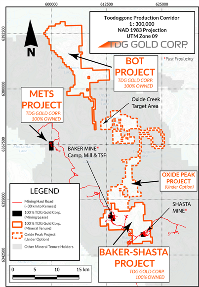
Figure 1 - TDG Gold Corp. Tenure Holdings in the Toodoggone, North-Central British Columbia.
2022 Diamond Drilling & Exploration Summary
Two HQ/NQ diameter DDH were completed towards the end of the 2022 field season, totaling 1,021.5 m. The two DDH completed targeted a short portion of a coincident 0.5 kilometre ("km") wide x 2 km long induced polarization ("IP") and aeromagnetic geophysical anomaly associated with a broad multi-element geochemical anomaly and mapped advanced argillic to intermediate argillic alteration assemblages. Both DDHs, intersected multiple, broad intervals of high to intermediate sulphidation mineral assemblages containing highly anomalous concentrations of Cu, zinc ("Zn"), molybdenum ("Mo") and locally lead ("Pb") and Au along with a suite of porphyry-style pathfinder elements (tellurium, tungsten and bismuth "Te", "W" & "Bi") and strong quartz sericite (illite)-pyrite ("QSP") style alteration. The combined data is suggestive of the presence of a porphyry Cu-Mo system in the vicinity1. Select intercepts are presented in Table 1 with DDH particulars in Table 2. Full DDH composite results are provided in Table 3.
Table 2 - Drillhole Particulars
HOLE |
UTME (NAD83) |
UTMN (NAD83) |
Azimuth(°) |
Dip(°) |
Final Depth (m) |
| OP22-001 | 611,546 |
6,372,427 |
255 |
-45 |
480.0 |
| OP22-002 | 611,546 |
6,372,427 |
255 |
-60 |
541.5 |
* Hole locations are approximate from handheld GPS.
** Both holes had minor deviations downhole from the collared orientations based on downhole surveys.
Table 3 - All 2022 Oxide Peak Composite Results
2022 SGS Analysis |
|||||||||
Hole |
From |
To |
Length |
Cu |
Pb |
Zn |
Mo |
Au |
Ag |
(m) |
(m) |
(m) |
(ppm) |
(ppm) |
(ppm) |
(ppm) |
(ppb) |
(ppm) |
|
OP22-001 |
19.0 |
116.0 |
97.0 |
233 |
38 |
488 |
9 |
63 |
0.51 |
incl |
90.0 |
104.0 |
14.0 |
637 |
30 |
1470 |
14 |
100 |
1.30 |
and |
135.0 |
169.4 |
34.4 |
453 |
8 |
168 |
13 |
21 |
0.32 |
incl |
139.0 |
164.0 |
25.0 |
534 |
7 |
103 |
14 |
24 |
0.36 |
and |
231.0 |
242.8 |
11.8 |
359 |
8 |
409 |
25 |
37 |
0.68 |
and |
283.3 |
295.6 |
12.3 |
191 |
8 |
138 |
4 |
12 |
0.36 |
and |
415.0 |
463.5 |
48.5 |
333 |
9 |
44 |
19 |
13 |
0.37 |
incl |
416.0 |
428.0 |
12.0 |
608 |
4 |
30 |
9 |
35 |
0.48 |
OP22-002 |
34.5 |
49.5 |
15.0 |
292 |
38 |
456 |
6 |
34 |
0.39 |
and |
61.5 |
100.5 |
39.0 |
244 |
22 |
889 |
15 |
73 |
0.56 |
and |
109.5 |
139.5 |
30.0 |
211 |
9 |
430 |
7 |
30 |
0.29 |
and |
222.3 |
294.3 |
72.1 |
819 |
5 |
61 |
12 |
83 |
0.37 |
incl |
236.0 |
249.0 |
13.0 |
2,324 |
5 |
74 |
10 |
328 |
0.72 |
incl |
264.0 |
276.0 |
12.0 |
565 |
6 |
51 |
11 |
32 |
0.32 |
incl |
285.0 |
294.3 |
9.3 |
841 |
7 |
43 |
15 |
36 |
0.45 |
and |
328.0 |
352.6 |
24.6 |
399 |
68 |
656 |
28 |
19 |
0.73 |
incl |
337.0 |
347.5 |
10.5 |
529 |
152 |
1498 |
18 |
30 |
1.22 |
and |
357.9 |
361.5 |
3.6 |
281 |
11 |
13 |
36 |
11 |
0.79 |
and |
390.8 |
423.0 |
32.2 |
658 |
4 |
27 |
37 |
20 |
0.59 |
incl |
414.0 |
423.0 |
9.1 |
1,648 |
4 |
34 |
37 |
35 |
1.38 |
and |
440.7 |
444.6 |
3.8 |
1,035 |
11 |
66 |
43 |
14 |
2.22 |
and |
476.9 |
511.5 |
34.6 |
465 |
4 |
38 |
12 |
13 |
0.54 |
incl |
490.0 |
500.9 |
10.9 |
846 |
4 |
31 |
21 |
22 |
0.84 |
and |
529.0 |
532.0 |
3.0 |
211 |
7 |
52 |
4 |
24 |
0.89 |
* Intervals are core-length weighted. True width is unknown and core recovery is estimated to be > 75 %.
** Composite results were built using a 150 ppm Cu cut-off, although there may be intervals with the composite below 150 ppm Cu.
*** Calculated composites are truncated to the nearest whole number for Cu, Pb, Zn, Mo, Au and Ag.
**** Values may not add due to rounding.
Past Exploration of Oxide Peak Target Area
Mineralization in the Oxide Peak area was recognized in the 1930s when nearby placer operators conducted stream sediment sampling and initial prospecting throughout the area. In the mid-1930s, Cominco reportedly identified the mineralization in the area during regional surveys. In the 1980s SEREM identified a broad area of highly anomalous stream sediment samples and traced the anomalous samples to their source area on a large iron oxide-stained ridge known as Oxide Peak.
A number of mineral occurrences1, including Oxide Peak are now known to occur along a north-northwest trending, poorly exposed, 10-km long belt of intense QSP altered volcanics and intrusive rocks, gossans and multiple dike swarms with variable compositions exhibiting alteration types and patterns typical of the upper levels of porphyry Cu-Mo systems. These altered and mineralized zones occur along the Takla-Toodoggone volcanics contact - a permissive and favorable site for porphyry systems within the Toodoggone Belt.
In 2020, TDG completed a detailed airborne radiometric and magnetic survey over the Oxide Peak property on 100 m line spacing. Ground survey work, including soil geochemistry and an IP survey and ground magnetic surveys.
These surveys outline a large multi-element geochemical anomaly coincident with the geophysical anomalies and mapped alteration. In mid-2022, a high precision airborne hyperspectral survey was conducted over the property to assist in mapping alteration mineralogy at the property scale. These surveys outlined a broad area exhibiting anomalous airborne hyperspectral signatures indicative of a large hydrothermally altered area, consistent with on-the-ground field observations by past operators and the TDG exploration team1.
Interpretation of Hyperspectral (SWIR) Survey Data
Previous operators conducted limited short wave infrared reflectance ("SWIR") analyses of outcropping exposures of altered intrusive, volcanics and volcaniclastics rocks on and adjacent to the property, identifying the presence of weak to moderate advanced argillic alteration including diapsore and pyrophyllite. These assemblages are typically found at high levels in hydrothermal systems, often associated with porphyry deposits. The zonation of major and trace elements and chemistry and crystallinity in muscovite, illite (a fine-grained white mica) and chlorites are typical of the alteration footprint for porphyry deposits and may provide an exploration tool for vectoring towards mineralization. Chemical variations in the chlorites and illites are partly reflected in the SWIR spectra in samples from Oxide Peak drilling and outcrops.
The aerial hyperspectral surveys at Oxide Peak provided dense, high quality hyperspectral (SWIR) data in the areas devoid of vegetation. The airborne surveys outline a large 500 m x 500 m multi-mineral hyperspectral anomaly that is open in all directions into vegetation covered areas centered on the area of the 2022 drilling. Processing of the spectral data indicate the illites and chlorites within the zone exhibit higher levels of crystallinity, suggesting high temperatures of formation, consistent with the drill results in the highly altered and sulphidized zones. High-temperature illite is suggestive of a nearby buried intrusion or alteration by higher temperature hydrothermal fluids1. The survey data also indicates the presence and zonation of phengitic to paragonitic illites which reflect the underlying chemical composition of the fine-grained white mica species. Chlorite, like illite, shows systematic variations in its chemical composition, which, among other exploration tools, are related to the formation temperature. High iron ("Fe") chlorite is the dominant chlorite type present in the hyperspectral survey of the prospect, but variations exist and may reflect subtle zonation patterns as well. Fe-rich gossans occur throughout the hill and are coincident and larger than the illite anomaly.
The hyperspectral data indicates the gossans in the drilled area are goethite dominant, hematite subordinate gossans are found on the western portions of the ridge with minor jarosite occurrences throughout the area. These variations may represent primary sulphide and rock composition variations, and may be related to alteration zonation and/or reflect weathering effects.
The hyperspectral analysis has also identified anomalous SWIR signatures in several north-northwest trending linear belts passing through the TDG properties including Oxide Peak. These anomalous hyperspectral features likely represent hydrothermal alteration zones potentially centered on subvolcanic intrusive rocks. A large area at TDG's past producing Baker Mine Complex (including the Drybrough target on the Oxide Peak property block) exhibit similar highly anomalous hyperspectral signatures and correspond with strong base and precious metal sample results from stream sediment sampling surveys by previous operators and TDG. Large poorly explored and undrilled geochemical, airborne geophysical and hyperspectral anomalies are also present elsewhere on the Oxide Peak property1.
2022 Diamond Drilling at Oxide Creek
In late summer 2022, an initial two drillhole program targeted a coincident zone of: (i) outcropping weak to moderate advanced argillic alteration assemblages identified by previous operators using hand-held SWIR instrument including pyrophyllite, diaspore, alunite, and kaolinite, (ii) a broad multi-element soil anomaly (Au, Cu-Figure 2, Pb, Zn, As), (iii) outcropping Fe oxide gossans, (iv) a linear northwest trending ground magnetic and aeromagnetic anomaly and, (v) a coincident 0.5 km wide x 2 km long IP chargeability anomaly.
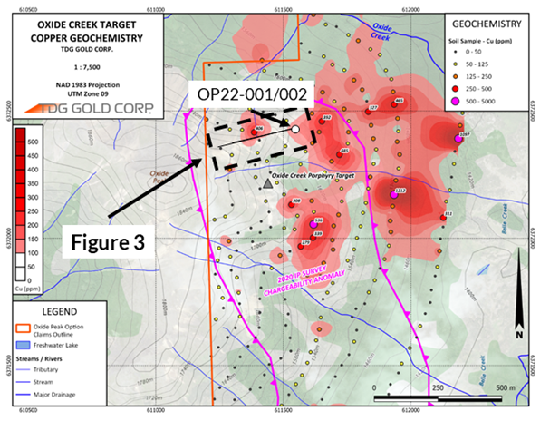
Figure 2 - Oxide Creek Drill area with Cu in Soil & IP Anomaly
Drilling successfully demonstrated the presence of seven lenses of intense illite-sulfide (pyrite) alteration hosted in intermediate to felsic volcanic and volcaniclastic rocks and possible intrusive dikes. These sulphidized zones range from approximately 5 m to 78 m drilled thickness and typically contain from 5-35 % pyrite with traces of bornite, chalcocite and occasional sphalerite. Cumulative thicknesses of these high sulfide content zones averages approximately 240 m drilled thickness between the two drillholes. The sulphidized assemblages are associated with zones of intense fracturing and illite alteration (Figure 3).
An oreXpress® portable SWIR scanner was utilized to characterize clay mineral assemblages and indicate high crystallinity illites are directly associated with and correlate well with the altered and sulphidized zones. Highly anomalous Au, Ag, Cu, Pb, Zn, Bi, Mo, Se, Te, and arsenic ("As") are associated with the intensely altered zones, typical of many porphyry Cu-Mo systems in the region and elsewhere. Extensive gypsum (calcium sulphate) veining was abundant in both holes at increasing depth. Gypsum veins and stockworks are often developed in the higher levels of subvolcanic porphyry systems. Structural information on veins, contacts and other structural elements collected during oriented core drilling is consistent with the geochemically and geologically interpreted mineralized zones.
Systematic magnetic susceptibility measurements on core indicates zones of alteration and sulfide enrichment generally have low magnetic susceptibility suggesting destruction of primary magnetite and mafic minerals during hydrothermal alteration. Magnetite-bearing intermediate to felsic porphyritic dikes locally crosscut the mineralized zones and have high magnetic susceptibility and are typically strongly magnetic. Zn and Cu concentrations demonstrate apparent zonation with higher Zn concentrations towards the top of the holes and higher Cu concentrations at depth and down dip towards the east - where a large 500 m x 500 m Cu-in-soils anomaly remains untested (Figure 2). Some of the porphyritic dikes also host Zn-rich mineralization suggesting multiple intrusive-related mineralization phases may be present1. Zn is often found in the distal portions of porphyry-Cu systems.
The upper portions of both holes intersected vuggy silica sucrosic textured oxidized to partially oxidized and montmorillonite and illite altered intermediate to felsic volcanic and volcaniclastic rocks. Montmorillonite and jarosite were common towards the top of both holes and were generally absent at depth. In the altered zones intersected in drilling, textures are often partially or completely obliterated by the intense alteration and dense fracturing. The geochemical data, textures and mineralogy suggest the holes likely penetrated distal porphyry-type alteration assemblages. This is consistent with and encouraging since intrusive hosted hydrothermal breccias with quartz-magnetite-chalcopyrite veins and relict potassic alteration outcrop at Oxide Creek along the northern end of the IP anomaly at lower elevations as does a large Cu-in-soils anomaly to the southeast and likely down dip on the sulfide-rich lenses.
QA/QC
Samples for the Oxide Peak 2022 drill program were handled via rigorous chain of custody, between collection, processing, and delivery to the SGS laboratory in Burnaby, B.C. The drill cores were delivered to the core shack at TDG's Baker Mine site and processed by geologists and technicians who verified down hole meterage blocks, photographed the core, recorded recovery, Rock Quality Data ("RQD"), logged lithology, alteration and captured oriented core structural information, inserted certified reference materials ("CRM's"), blanks and duplicates (coarse) into the sampling sequence. The 2022 drill core was cut in half (1/2 HQ/NQ core) and placed in zip-tied polyurethane bags, then in security-sealed rice bags before being delivered directly from the Baker Mine site, to Bandstra Transportation Systems in Prince George, B.C., and transported to SGS' facility in Burnaby, B.C. Samples were prepared and analyzed following procedures: GE_FAI50V5, GE_ICP21B20/GE_IMS21B20, GE_ICP90A50/GE_IMS90A50 and GE_CSA06V for sulphur and carbon analysis. Information about methodology can be found on the SGS Canada Inc. website, in the analytical guide(here).
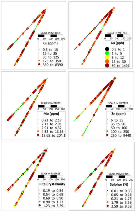
Figure 3 - Oxide Creek DDH Cross-sections (warm colours represent 20th percentiles ranges, looking northwest).
Quality assurance and control ("QAQC") is maintained internally at the lab through rigorous use of internal certified reference materials, blanks, and duplicates. An additional QAQC program was administered by TDG through the insertion and verification of lab results via use of certified reference materials ("CRMs"), duplicate samples and blank (unmineralized) samples that were blindly inserted into the sample batch. If a QAQC sample returns an unacceptable value an investigation into the results is triggered and when deemed necessary, the samples that were tested in the batch with the failed QAQC sample are re-tested.
Qualified Persons
The geologically related technical content of this new release has been reviewed and approved by Steven Kramar, P.Geo., Vice President, Exploration for TDG and a Qualified Person, as defined under National Instrument 43-101.
1Mineral Exploration/Exploration Target Area(s): TDG is a mineral exploration focused company and the Company's Projects are in the mineral exploration stage only. The degree of risk increases substantially where an issuer's properties are in the mineral exploration stage as opposed to the development or operational stage. Exploration Targets and/or Exploration zones are speculative and there is no certainty that any future work or evaluation will lead to the definition of a mineral resource.
About TDG Gold Corp.
TDG is a major mineral and placer tenure holder in the historical Toodoggone Production Corridor of north-central British Columbia, Canada, with over 23,000 hectares of brownfield and greenfield exploration opportunities under direct ownership or earn-in agreement. TDG's flagship projects are the former producing, high-grade gold-silver Shasta, Mets and Baker mines, which are all road accessible, produced intermittently between 1981-2012, and have over 65,000 m of historical4,5 drilling. The projects have been advanced through compilation of historical4 data, new geological mapping, geochemical and geophysical surveys and, at Shasta 13,250 m of modern HQ drill testing of the known mineralization occurrences and their potential extensions. In May 2023, TDG published an updated Mineral Resource Estimate for Shasta (see TDG news release May 01, 2023) and which remains open at depth and along strike. In January 2023, TDG defined a larger exploration target area adjacent to Shasta (Greater Shasta-Newberry; see TDG news release January 25, 2023) with drill-ready targets where TDG aims to undertake follow-up exploration activities in 2023.
ON BEHALF OF THE BOARD
Fletcher Morgan
Chief Executive Officer
For further information contact:
TDG Gold Corp.,
Telephone: +1.604.536.2711
Email: info@tdggold.com
Neither TSX Venture Exchange nor its Regulation Services Provider (as that term is defined in the policies of the TSX Venture Exchange) accepts responsibility for the adequacy or accuracy of this release.
Forward Looking Statements
This news release contains forward-looking statements that are based on the Company's current expectations and estimates. Forward-looking statements are frequently characterized by words such as "prospective", "suggest", "indicates", "represent" "reflect", "identified", "potential", "demonstrated", "exhibit", and variations of these words as well as other similar words or statements that certain events or conditions "could", "may", "would" or "will" occur. Such forward-looking statements involve known and unknown risks, uncertainties and other factors that could cause actual events or results to differ materially from estimated or anticipated events or results implied or expressed in such forward-looking statements. Such factors include, among others: the actual results of current and planned exploration activities; the potential for a discovery of a porphyry-Cu or other style of deposit of minerals of economic grade; results from future exploration programs); that geological and/or geophysical anomalies remain open (in any direction); conclusions of future economic evaluations; changes in project parameters as plans to continue to be refined; possible variations in grades of mineralization and/or future actual recovery rates; accidents, labour disputes and other risks of the mining industry; the availability of sufficient funding on terms acceptable to the company to complete the planned work programs; delays in obtaining governmental approvals or financing; and fluctuations in metal prices. There may be other factors that cause actions, events or results not to be as anticipated, estimated or intended. Any forward-looking statement speaks only as of the date on which it is made and, except as may be required by applicable securities laws, the Company disclaims any intent or obligation to update any forward-looking statement, whether as a result of new information, future events or results or otherwise. Forward-looking statements are not guarantees of future performance and accordingly undue reliance should not be put on such statements due to the inherent uncertainty therein.
SOURCE: TDG Gold Corp.
View source version on accesswire.com:
https://www.accesswire.com/758548/TDG-Gold-Corp-Intersects-Porphyry-Style-Mineralization-at-Oxide-Creek-Toodoggone-District-BC