TORONTO, ON / ACCESSWIRE / February 28, 2022 / Avidian Gold Corp. (" Avidian " or the " Company ") (TSX-V:AVG)(OTCQB:AVGDF) is pleased to provide an update from the Copper King/Long Creek 2021 reverse-circulation ("RC") drilling program at its district-scale (125.5 sq. km) Glden Zone Project (Figure 1) strategically located in south-central Alaska midway between Anchorage and Fairbanks only 10 km west of paved State Highway 3, the Alaska Railroad and the 345 kV Alaska Intertie power lines.
A total of 1,512.54 m in ten (10) RC holes were drilled within the Copper King/Long Creek area as a follow-up to the previous drilling to test the continuity of a known mineralized conglomeratic unit and geophysical targets related to a large magnetic low and CSAMT Impedance anomaly which defined near-surface resistivity highs that are interpreted to be intrusions into overlying sediments, all within the vicinity of a quartz-eye granite porphyry.
The Copper King/Long Creek area occurs in the Long Creek mineralized corridor, which is characterized by Cu-Au-Ag mineralization in a variety of geological settings over a 2 km long strike length (Figure 2). Mineralization is typically proximal to a distinct quartz-eye granite porphyry which locally contains disseminated molybdenite and chalcopyrite. Mineralization styles at Copper King occurring within 250 m of the main granite outcrop include: i) replacement mineralization in conglomerate such as seen in T18-11 that encountered 21.0 m @ 0.13 g/t Au, 13.1 g/t Ag, and 0.45% Cu and 3.0 m @ 16.08 g/t Au, 50.6 g/t Ag and 0.78% Cu in T18-05; ii) massive sulphide skarn mineralization such as 9.1 m @ 8.71 g/t Au, 80.8 g/t Ag, 3.57% Cu in hole CK18-01; iii) stockwork quartz mineralization such as in a grab sample that returned 4.8 g/t Au, 106 g/t Ag, 1.41% Cu ; iv) quartz-sulphide vein mineralization as seen in historic hole CK-94-2 that returned 6.1 m @ 1.09 g/t Au, 9.17 g/t Ag and 0.36% Cu ; and mafic dike-related mineralization as in a grab sample that returned 1.44 g/t Au, 87.5 g/t Ag , 3.29% Cu .
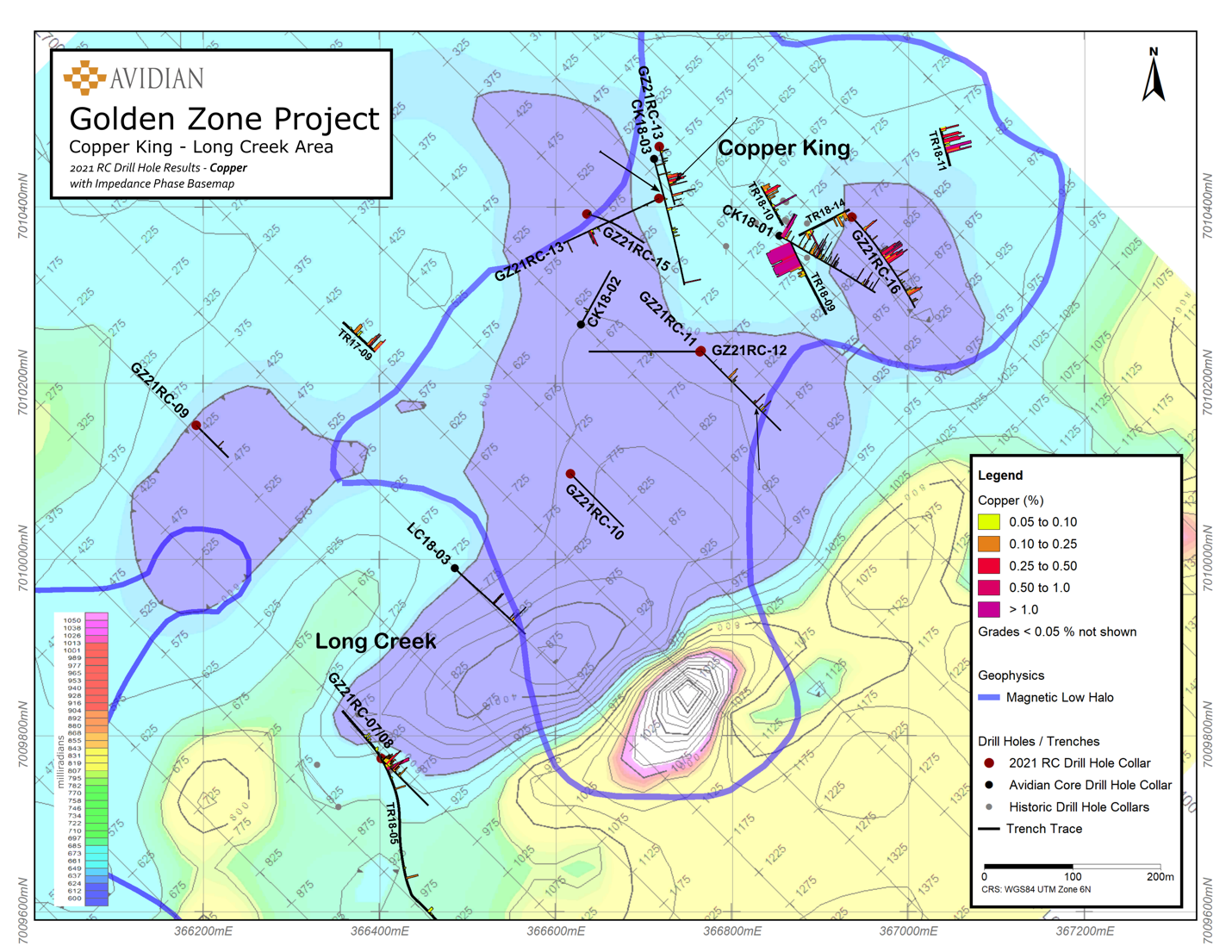
Drilling in the Copper King/Long Creek area in 2021 focused on two main targets. The first is replacement mineralization within a conglomerate horizon (Style i as above) that is intermittently exposed over a strike length of 2 km as this conglomerate is known to contain significant mineralization locally as noted above. The drilling program only tested the northeastern portion of the conglomerate horizon (5 holes) over a strike length of approximately 1 km at a minimum 200 m spacing (see Figure 3) with significantly anomalous Cu, Ag, and Au noted in 4 of 5 holes such as 10.67 m @ 0.51 g/t Au, 7.3 g/t Ag and 0.19 % Cu including 1.52 m @ 2.23 g/t Au, 18.3 g/t Ag and 0.43% Cu in hole GZ21RC-07. The second target is mineralization more clearly related to the quartz-eye porphyry granite (Styles ii to iv as above) in the vicinity of a CSAMT Impedance anomaly. Hole GZ21RC-13 encountered 6.1 m @ 0.36 g/t Au, 16.7 g/t Ag and 0.23% Cu , and 4.57 m @ 0.81 g/t Au including 1.53 m @ 1.68 g/t Au ( Figure 3). The granite was also found to be much more extensive than previously known, and the distribution of molybdenite is also more widespread.
Steve Roebuck, President & CEO states: " The 2021 drilling results suggest that in the Copper King & Long Creek area, a nearby mineralized intrusive provided gold, copper and silver-bearing solutions that precipitated into favourable permeable sedimentary units that can be traced for over 2 km and that could ultimately host a copper, gold plus silver deposit. In addition, all indications are that the source intrusive is likely at a relatively shallow depth and that modestly deeper drilling will be required to test it as it is this type of target that could host a large deposit. These results in conjunction with the previous results reported on the property clearly show its potential to host one or more significant deposits ".
Drill Results Discussion
Three (3) holes were drilled in the Long Creek prospect in 2021, with holes GZ21RC-07 & 08 being the two southernmost holes, drilled from the same location near trench TR18-05 that encountered 3.0 m @ 16.08 g/t Au, 50.6 g/t Ag and 0.78% Cu (Figure 3). These two holes were drilled to test potential replacement style mineralization in the northeast-trending conglomerate along strike to the southwest of the Copper King prospect and are also located near the southeast edge of a large CSAMT Impedance anomaly (Figure 4). Hole GZ21RC-07 drilled 10.67 m @ 0.51 g/t Au, 7.3 g/t Ag and 0.19% Cu including 1.52 m @ 2.23 g/t Au, 18.3 g/t Ag and 0.43% Cu hosted in the conglomerate within the upper portion of the hole from 4.57 to 15.24 m. GZ21RC-08 was drilled at a steeper angle (-60°), intersecting the conglomerate from 7.62 m to 15.24 but the zone only contained moderately elevated silver, copper and zinc values with the best interval containing 1.53 m @ 4.3 g/t Ag, 0.15% Cu. A second mineralized interval possibly associated with a narrow structure intersected 3.05 m grading 5.9 g/t Ag and 0.16% Cu.
Drill hole GZ21RC-09 targeted a large CSAMT Impedance anomaly and was exclusively hosted in relatively unaltered sediments (siltstone and sandstone) with 3.04 m @ 0.13 g/t Au and 6.9 g/t Ag including 1.52 m @ 0.1 g/t Au, 13.2 g/t Ag and 0.12% Cu (Figures 3 & 4). This zone also contained slightly elevated copper and zinc values. This hole was stopped 120 m short of the intended depth due to difficult drilling conditions and did not properly test the CSAMT Impedance anomaly at depth.
Seven (7) holes (GZ21RC-10 through 16) were drilled in the Copper King prospect area (Figure 3). Drill hole GZ21RC-10 targeted the interpreted northeast-trending mineralized conglomerate within a large CSAMT Impedance anomaly as well as being on the southwest flank of a magnetic low (Figure 4). The hole intersected a thick sequence of siltstone and sandstone cut by minor granite dikes containing <1% quartz veining and trace amounts of pyrite and rare molybdenite. Only a minor percentage of the expected conglomerate was encountered. Metal values were generally low.
Drill holes GZ21RC-11 & 12 are located 200 m northeast of GZ21RC-10 and were drilled from the same site, with hole G21RC-11 drilled to the southeast to test the mineralized conglomerate along strike and a CSAMT Impedance anomaly. Four conglomerate horizons were intersected with all zones containing anomalous gold, silver, and copper values along with a zone of elevated tungsten and zinc. The best interval was hosted in sandstone and returned 1.52 m @ 0.44 g/t Au, 130 g/t Ag, and 0.26 % Cu. GZ21RC-12 was drilled to the west targeting mineralization in sediments proximal to a quartz-eye porphyritic granite. The hole drilled through a thick sequence of sandstone and siltstone with minor granite dikes. Minor quartz veining, trace sulfides, and iron oxides were encountered along with one interval of 1.53 m @ 0.15 g/t Au .
GZ21RC-13 and GZ21RC-14 tested the sedimentary package of rocks in the vicinity of a quartz stockwork granite previously drilled in nearby hole CK18-03 that intersected 1.22 m @ 10.1 g/t Au to assist in vectoring of the intrusive source responsible for the mineralization in this area. GZ21RC-13 was drilled southwest and is located on the edge of both a CSAMT Impedance anomaly and a magnetic low. The hole drilled through 110 m of granite before intersecting sediments containing two mineralized zones including 6.1 m @ 0.36 g/t Au, 16.7 g/t Ag and 0.23 % Cu , and 4.57 m @ 0.81 g/t Au including 1.53 m @ 1.68 g/t Au . These mineralized zones are associated with an increase in iron oxides, and hydrothermal quartz surrounding clasts. This hole also had elevated tungsten throughout the granitic zone with sporadic spikes up to 1,560 ppm W. GZ21RC-14 was drilled to the SSE and intersected mostly sediments with minor granite dikes and showed increased alteration intensity along with abundant intervals containing trace to 3% sulfides including pyrite, chalcopyrite, and molybdenite. Two mineralized zones returned 27.43 m @ 0.38 g/t Au, 4.7 g/t Ag and 0.18% Cu and 4.57 m @ 0.2 g/t Au , 8.0 g/t Ag and 0.36% Cu including 1.52 m @ 0.36 g/t Au, 15.3 g/t Ag and 0.36% Cu.
GZ21RC-15 was drilled in the vicinity of holes 13 &14 to test the quartz stockwork zone in the quartz-eye porphyry granite. Previous hole CK18-02 attempted to test the same quartz stockwork zone but fell short due to drilling difficulties. Hole GZ21RC-15 only encountered 25.9 m of granite near the top of the hole before drilling through sediments containing only anomalous gold and silver values.
GZ21RC-16 targeted the mineralized conglomerate, a CSAMT Impedance anomaly and a magnetic low (Figure 4). The hole was collared 85 m northeast of GZ18-01 that intersected 9.1 m @ 8.71 g/t Au, 80.8 g/t Ag, and 3.57% Cu from 3.9 m to 13.0 m. GZ21RC-16 intersected a thick package of siltstones and sandstones with minor interbedded conglomerates. This hole encountered five mineralized zones that are anomalous in gold but contain higher silver and copper grades that appear to occur within the zones that also contain interbedded conglomerates. These mineralized zones returned 3.05 m @ 13.0 g/t Ag and 0.29% Cu ; 22.86 m @ 16.0 g/t Ag and 0.39% Cu including 3.05 m @ 0.25 g/t Au, 27.0 g/t Ag and 0.56% Cu ; 6.09 m @ 0.56 g/t Au ; 1.53 m @ 0.30 g/t Au and 63.8 g/t Ag ; and 7.62 m @ 0.21% Cu.
It should also be noted that, due to their selective nature, assay results from grab samples noted in this release may not be representative of the overall grade and extent of mineralization on the subject areas.
The following table outlines highlight intercepts from the Copper King/Long Creek portion of the 2021 RC drill program.
Hole ID | EOH (m) | Azimuth (deg.) | Dip (deg.) | From (m) | To (m) | Length (m) | Grade (g/t Au) | Grade (g/t Ag) | Grade (% Cu) |
GZ21RC-07 | 117.35 | 135 | 50 | 4.57 | 15.24 | 10.67 | 0.51 | 7.30 | 0.19 |
incl | 13.72 | 15.24 | 1.52 | 2.23 | 18.30 | 0.43 | |||
GZ21RC-08 | 103.63 | 135 | 60 | 6.10 | 13.72 | 7.62 | NSV | 4.10 | 0.11 |
54.86 | 57.91 | 3.05 | NSV | 5.90 | 0.16 | ||||
GZ21RC-09 | 80.77 | 135 | 50 | 51.82 | 54.86 | 3.04 | 0.13 | 6.90 | |
incl | 53.34 | 54.86 | 1.52 | 0.10 | 13.20 | 0.12 | |||
GZ21RC-10 | 132.59 | 135 | 50 | NSV | |||||
GZ21RC-11 | 199.64 | 135 | 50 | 56.39 | 57.91 | 1.52 | 0.20 | 5.40 | |
67.06 | 70.10 | 3.04 | 0.10 | 4.40 | 0.19 | ||||
132.59 | 134.11 | 1.52 | 0.44 | 130.00 | 0.26 | ||||
149.35 | 150.88 | 1.53 | 0.12 | 5.10 | 0.25 | ||||
GZ21RC-12 | 199.64 | 270 | 50 | 85.34 | 86.87 | 1.53 | 0.15 | ||
GZ21RC-13 | 195.07 | 245 | 52 | 138.68 | 144.78 | 6.10 | 0.36 | 16.70 | 0.23 |
185.93 | 190.50 | 4.57 | 0.81 | ||||||
incl | 187.45 | 188.98 | 1.53 | 1.68 | |||||
GZ21RC-14 | 137.16 | 165 | 60 | 68.58 | 96.01 | 27.43 | 0.38 | 4.70 | 0.18 |
incl | 71.63 | 76.20 | 4.57 | 0.45 | 6.30 | 0.27 | |||
incl | 80.77 | 85.34 | 4.57 | 0.56 | 7.40 | 0.26 | |||
incl | 89.92 | 96.01 | 6.09 | 0.57 | 3.50 | 0.14 | |||
112.78 | 117.35 | 4.57 | 0.20 | 8.00 | 0.36 | ||||
incl | 112.78 | 114.30 | 1.52 | 0.36 | 15.30 | 0.74 | |||
GZ21RC-15 | 152.4 | 105 | 60 | 57.91 | 60.96 | 3.05 | 0.20 | 4.40 | |
GZ21RC-16 | 194.29 | 135 | 50 | 30.48 | 33.53 | 3.05 | NSV | 13.00 | 0.29 |
80.77 | 103.63 | 22.86 | 0.06 | 16.00 | 0.39 | ||||
incl | 100.58 | 103.63 | 3.05 | 0.25 | 27.00 | 0.56 | |||
105.16 | 111.25 | 6.09 | 0.56 | ||||||
146.30 | 147.83 | 1.53 | 0.30 | 63.80 | |||||
163.07 | 170.69 | 7.62 | NSV | 0.21 | |||||
| *No Significant Value (NSV) | |||||||||
All assays reported in this table are presented in drilled length at this time as there is insufficient data concerning the orientation of the mineralized intersections to calculate true widths.
Background Information on the Golden Zone Property
The property lies within the prolific gold endowed Tintina Gold Belt with mineralization styles on the property directly associated with Intrusive Related Gold System ("IRGS") deposits with numerous polymetallic, gold-dominated showings contained within three fault-bounded belts or corridors. All the known mineralization is spatially associated with Cretaceous age intrusive rocks, analogous to what is observed in many of the large gold deposits within the Tintina Gold Belt. The mineralized occurrences on the project extend for well over 19 km of strike length. There are several regional-scale exploration targets in the central and southern portions of the property for gold-copper mineralization.
The property also hosts a NI 43-101 Indicated gold resource of 267,400 ounces (4,187,000 tonnes at 1.99 g/t Au) plus an Inferred gold resource of 35,900 ounces (1,353,000 tonnes at 0.83 g/t Au) within the Breccia Pipe Deposit . This resource is exposed on the surface and was pit constrained for an open-pit mining scenario. The Technical Report was filed on November 17, 2017, and was authored by Leon McGarry, B.Sc., P.Geo. and Ian D. Trinder, M.Sc., P.Geo.
Quality Control/Quality Assurance
Sampling included insertion of certified standards and blanks into the stream of samples for chemical analysis. Every twentieth sample was a standard or a blank. Due to the global sample preparation and assay backlog, samples were prepared at ALS Global's laboratory in either Fairbanks, Alaska; Hermosillo, Mexico; or Thunder Bay, Ontario, Canada and shipped to their Vancouver facility for gold analysis by fire assay and other elements by ICP analysis. ALS is a certified and accredited laboratory service. Gold values varied from below detection to a high of 15.60 g/t Au and silver values ranged from below detection to a high of 130.0 g/t Ag.
About Avidian Gold Corp.
Avidian brings a disciplined and veteran team of project managers together with a focus on advanced-stage gold exploration projects in Alaska. Additional projects include the Amanita and the Amanita NE gold properties which are both adjacent to Kinross Gold's Fort Knox gold mine in Alaska, and the Jungo gold-copper property in Nevada.
Avidian is a major shareholder of High Tide Resources (CSE: HTRC) an exploration stage company, that is focused on and committed to, the development of advanced-stage mineral projects in Canada using industry best practices combined with a strong social license from local communities. High Tide is earning a 100% interest in the Labrador West Iron project located adjacent to IOC/Rio Tinto's 23 mtpy Carol Lake Mine in Labrador City, Labrador and owns a 100% interest in the Lac Pegma copper-nickel-cobalt deposit located 50 km southeast of Fermont, Quebec.
Further details on the Company and the individual projects, including the NI 43-101 Technical reports on the Golden Zone property and Labrador West Iron property can be found on the Company's website at www.avidiangold.com.
Qualified Person
The technical information contained in this news release has been approved by Steve Roebuck, P.Geo., President and CEO of Avidian, who is a Qualified Person as defined in "National Instrument 43-101, Standards of Disclosure for Mineral Projects."
For further information, please contact:
Steve Roebuck
President & CEO, Director
Mobile: (905) 741-5458
Email: sroebuck@avidiangold.com
Neither TSX Venture Exchange nor its Regulation Services Provider (as that term is defined in the policies of the TSX Venture Exchange) accepts responsibility for the adequacy or accuracy of this news release.
Forward-looking information
This News Release includes certain "forward-looking statements" which are not comprised of historical facts including statements regarding the use of proceeds. Forward-looking statements include estimates and statements that describe the Company's future plans, objectives or goals, including words to the effect that the Company or management expects a stated condition or result to occur. Forward-looking statements may be identified by such terms as "believes", "anticipates", "expects", "estimates", "may", "could", "would", "will", or "plan". Since forward-looking statements are based on assumptions and address future events and conditions, by their very nature they involve inherent risks and uncertainties. Although these statements are based on information currently available to the Company, the Company provides no assurance that actual results will meet management's expectations. Risks, uncertainties and other factors involved with forward-looking information could cause actual events, results, performance, prospects and opportunities to differ materially from those expressed or implied by such forward-looking information. Forward looking information in this news release includes, but is not limited to, the Company's objectives, goals or future plans, statements, exploration results, potential mineralization, the estimation of mineral resources, exploration and mine development plans, timing of the commencement of operations and estimates of market conditions. Factors that could cause actual results to differ materially from such forward-looking information include, but are not limited to: the ability to anticipate and counteract the effects of COVID-19 pandemic on the business of the Company, including without limitation the effects of COVID-19 on the capital markets, commodity prices supply chain disruptions, restrictions on labour and workplace attendance and local and international travel, failure to receive requisite approvals in respect of the foregoing, failure to identify mineral resources, failure to convert estimated mineral resources to reserves, the inability to complete a feasibility study which recommends a production decision, the preliminary nature of metallurgical test results, delays in obtaining or failures to obtain required governmental, environmental or other project approvals, political risks, inability to fulfill the duty to accommodate First Nations and other indigenous peoples, uncertainties relating to the availability and costs of financing needed in the future, changes in equity markets, inflation, changes in exchange rates, fluctuations in commodity prices, delays in the development of projects, capital and operating costs varying significantly from estimates and the other risks involved in the mineral exploration and development industry, and those risks set out in the Company's public documents filed on SEDAR. Although the Company believes that the assumptions and factors used in preparing the forward-looking information in this news release are reasonable, undue reliance should not be placed on such information, which only applies as of the date of this news release, and no assurance can be given that such events will occur in the disclosed time frames or at all. The Company disclaims any intention or obligation to update or revise any forward-looking information, whether as a result of new information, future events or otherwise, other than as required by law.
Figure 1: Golden Zone Property
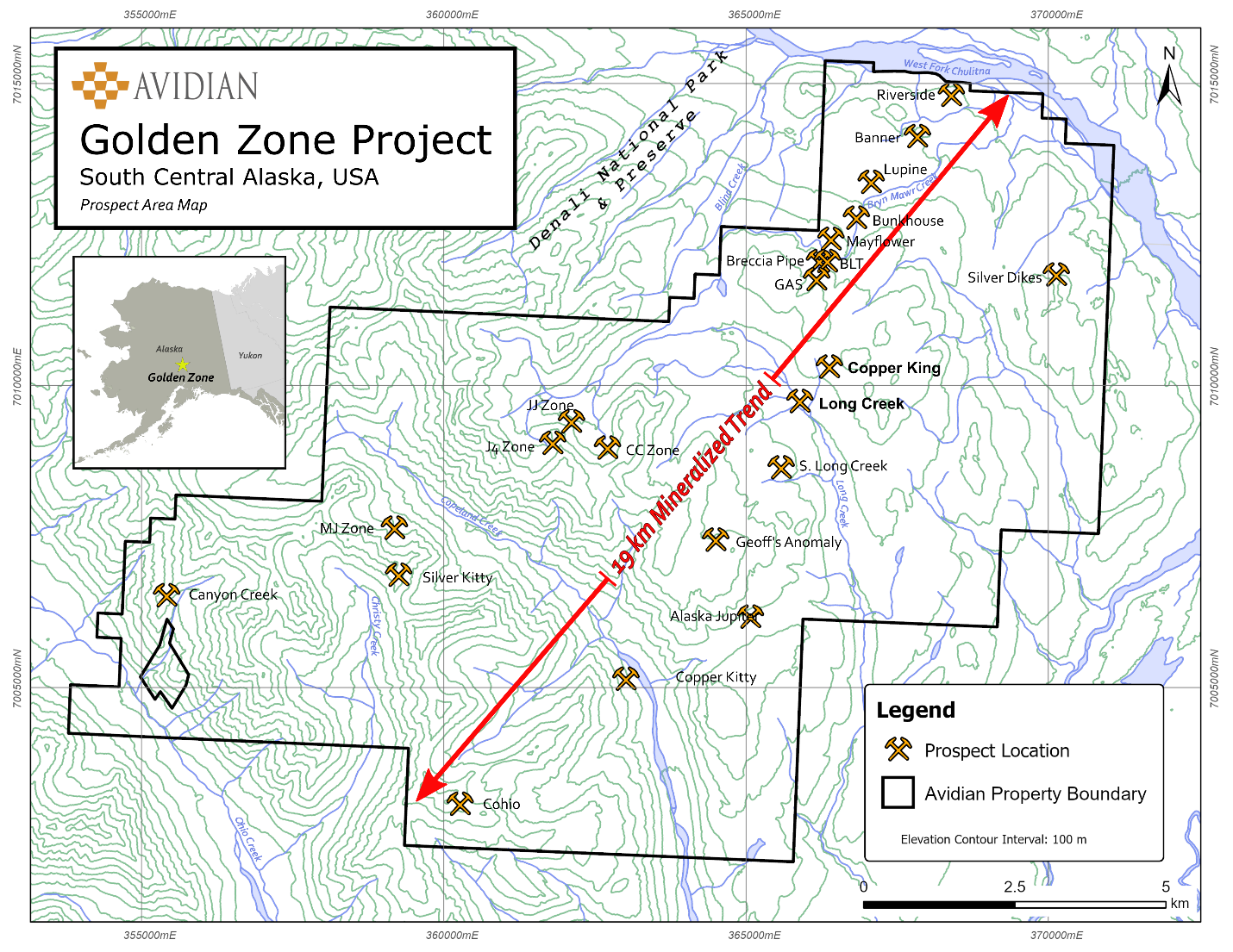
Figure 2: 2 km Long Generalized Conglomeratic Unit
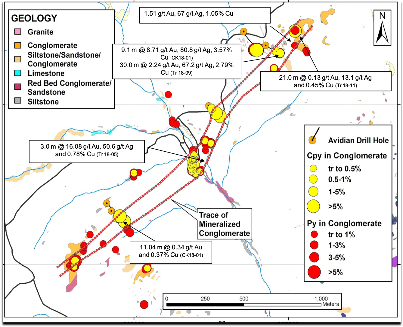
Figure 3: 2021 Copper King/Long Creek Drill Hole Locations
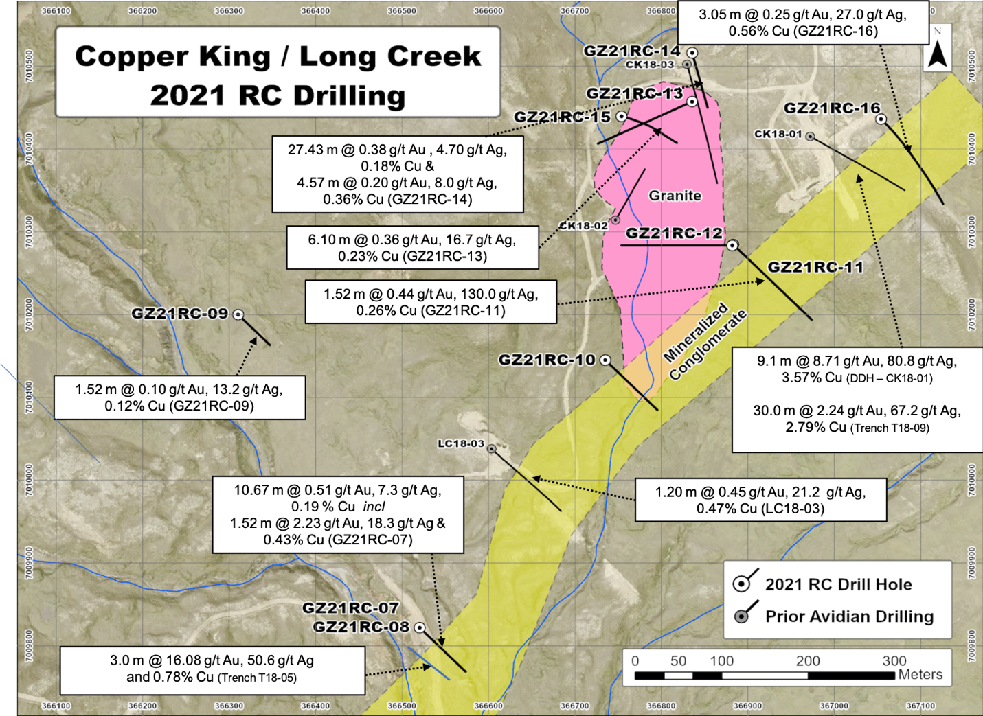
Figure 4: Impedance Anomaly
SOURCE: Avidian Gold Corp.
View source version on accesswire.com:
https://www.accesswire.com/690594/Avidian-Continues-to-Encounter-Au-Cu-Ag-Mineralization-at-the-Copper-King-Prospect-on-its-Golden-Zone-Project-Alaska